
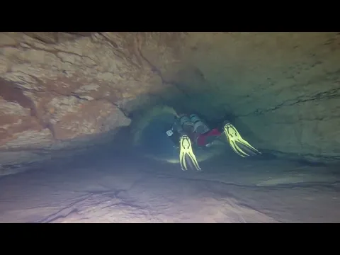
Ardèche · about 7 km from Saint-Ambroix
Peyraou de Chadouillet
- Max depth78 m
- CertificationFull cave
- Water temperature≈ 12.5–13 °Cestimated, no reports yet
- SpecialSidemount
Diving and fills
Dive here with
No dive centre guides here yet. Do you dive here with guests? Add your centre for free →
What it looks like
plongée souterraine Peyraou de Chadouillet - Siphon Nord Plongée à CHADOUILLET Peyraou de Chadouillet 24-02-2013 : Peyraou de Chadouillet
All 4 videos and posts
Videos and posts
From other divers, via YouTube, Instagram and Facebook. They only load when you click; after that, Google's or Meta's privacy rules apply.
plongée souterraine Peyraou de Chadouillet - Siphon Nord Plongée à CHADOUILLET Peyraou de Chadouillet 24-02-2013 : Peyraou de Chadouillet
Search for more onYouTube ↗Instagram ↗Facebook ↗
Other people's footage, not advice: how someone else dives here says nothing about what suits your team. Dive within your training.
The dive
A Vauclusian shaft on the underground course of the Claysse, with water of about 12.5–13 °C. The shaft lies downstream of the Sauvas–Peyrejal–Cocalière system and upstream of the résurgence du Moulin.
Profile and sections
A Vauclusian shaft on the underground course of the Claysse, with water of about 12.5–13 °C.
The shaft lies downstream of the Sauvas–Peyrejal–Cocalière system and upstream of the résurgence du Moulin. The first dives were in 1955; on 24 Jul 1955 a fatal accident happened here, the third cave-diving death in France. Trimix expeditions followed in 1999–2001 and rebreathers from 2005, including Volanthen and Stanton in 2006.
- Depth and profile
- Siphon Nord to -78 m, 1,020 m long (CDS07 2021): entry down a gravel/silt slope to -7 m, then a low bedding plane into a fracture; sections 2 × 1.5 to 4 × 3 m · Bertrand Léger branch (SW): S1–S8, 18–118 m long, mostly -2 to -6 m, S8 -18 m; ends in a boulder choke at 1,004 m · total 2,141 m (CDS07); fiche: -87 m vertical range
- Configuration
- Sidemount: low bedding planes in the Siphon Nord, and S1 of the Léger branch requires taking your kit off. For the deep Siphon Nord, CCR with trimix (explored with rebreathers since 2005).
- DPV: Not DPV-suitable (estimate)
- Clayey low bedding planes and short sumps in the Léger branch; not a scooter dive.
Who can dive where
- At least Full cave
- Configurations: Backmount / twinset / Sidemount / CCR / Small cylinders / no-mount (speleo sumps)
- Goes down to 78 m (trimix or deco may be needed)
- Experienced divers only
This is how the planner decides who in your team may dive this cave. Rules your own trip adds (organizer, a mail, the AI) show with your trip.
How to get there
From Saint-André-de-Cruzières go to the hamlet of Chadouillet, turn left at the (former) phone booth between the houses; signs 'Event de Peyrejal'/'Côtepatière'. Leave the car at the bridge and walk the dry bed of the Claysse; a slope of rounded pebbles leads down to a small, clear spring pool.
Around Peyraou de Chadouillet
FillsNo fill station known nearby
The links to Booking.com are affiliate links: if you book through one, DiveTripPlanner earns a small commission. You pay the same.
Going to the Ardèche with your team?
Marcel finds the sites that match your team's certifications.
Plan a trip