
Greece
Kolethra (Agios Vlasios, Evia)
- CertificationFull cave
- Water temperature≈ ~12 °Cestimated, no reports yet
Diving and fills
Dive here with
No dive centre guides here yet. Do you dive here with guests? Add your centre for free →
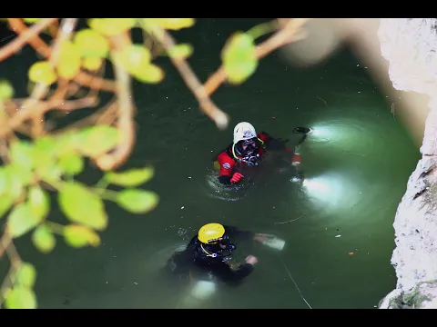
What it looks like
All 1 videos and posts
Videos and posts
From other divers, via YouTube, Instagram and Facebook. They only load when you click; after that, Google's or Meta's privacy rules apply.
Videos shown with permission from the channel @addicted2h2o ↗
Search for more onYouTube ↗Instagram ↗Facebook ↗
Other people's footage, not advice: how someone else dives here says nothing about what suits your team. Dive within your training.
The dive
Behind the spring opens a spacious cave of large chambers and high, wide passages that runs roughly north. You follow one main route between the rocks, with no tight passages or complex maze.
Profile and sections
Behind the spring opens a spacious cave of large chambers and high, wide passages that runs roughly north. You follow one main route between the rocks, with no tight passages or complex maze. As far as daylight reaches there are plants, and you often meet small eels and fish; the water averages 12 °C all year round (Grafas).
Kolethra is one of the largest springs on Evia and supplies eleven villages with water. It collects the groundwater of Mount Mavrovouni (1,190 m), the eastern end of Dirfys, and belongs to a karst area full of smaller springs, streams and sinkholes. In winter and spring the spring forms a lake with a fast stream that reaches the Manikiatis river after ~3 km. Members of the Hellenic Speleological and Exploration Club explored the first 300 m in 1989–1990; from 2007 a new team went further, to 950 m by 2009, and in 2013 Greek cave divers reached 1,500 m, then a Greek record. How far the cave goes is unknown. Grafas Diving filmed the cave in 2017; Addicted2H2O dived it in 2017, 2018 and 2021. The water is home to the Evia chub (Squalius sp. Evia), a fish found nowhere else (Amazing Evia).
Practical: the cultural association of Agios Vlasios has made a small picnic area at the entrance. From there a 300 m path follows the stream and old channels to a water mill that still works.
- Depth and profile
- No maximum depth published: Grafas describes a depth that keeps changing, around -25 m or deeper, and near the entrance an old drill pipe lies at -26 m. Explored to 1,500 m (2013); Amazing Evia gives ~1,240 m of mapped passage, with four chambers ~30 m high and 50 m wide.
- Configuration
- Spacious chambers and passages without tight squeezes (Grafas): all configurations (estimate).
- DPV: DPV possible (estimate)
- Long (1.5 km explored) and roomy, but visibility is always low.
Who can dive where
- At least Full cave
- Configurations: Backmount / twinset / Sidemount / CCR / Small cylinders / no-mount (speleo sumps)
This is how the planner decides who in your team may dive this cave. Rules your own trip adds (organizer, a mail, the AI) show with your trip.
How to get there
The spring lies at the foot of a rock face near Agios Vlasios, between Konistres and Lakos in central Evia, ~12 km south of Kymi, right by the paved road from Aliveri to Kymi. Parking next to the entrance. ~137 km from Athens (Addicted2H2O; Amazing Evia: ~120 km, ~2 h drive). No dive centre offers cave dives here; no permit rule is known.
Around Kolethra (Agios Vlasios, Evia)
FillsNo fill station known nearby
Going to Greece with your team?
Marcel finds the sites that match your team's certifications.
Plan a trip