
Roussillon and Aude · about 2 km from Villefranche-de-Conflent
Grotte d'En Gorner
- Max depth42 m
- CertificationFull cave
- Water temperature≈ ~11 °Cestimated, no reports yet
- SpecialDPV-suitable
Diving and fills
Dive here with
No dive centre guides here yet. Do you dive here with guests? Add your centre for free →
Fills nearby
- Fill stationCAP Port-Vendres (Centre d'Activité Plongée)Air, nitrox 32/40/50, oxygen, trimix and CCR fills up to 300 bar (surcharge above 230 bar); custom blends too (O₂ and helium per m³)Route ↗
- Fill stationCAP Port-Vendres (Centre d'Activité Plongée)Air, nitrox 32/40/50, oxygen, trimix; up to 300 bar (surcharge above 230 bar); CCR fill packageRoute ↗
- Fill stationPlongée Bleue (Banyuls-sur-Mer)Air, nitrox (membrane) and oxygen (B50 cylinders, booster for CCR) up to 300 bar; trimix not listed — askRoute ↗
What it looks like
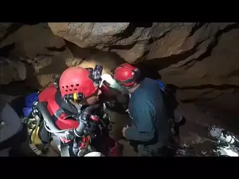
En Gorner départ des plongeurs En Gorner arrivée des plongeurs Spéléo Plongée : Découverte d'En Gorner #explorer #cave #nature grotte d'en gorner (spéléo)
All 4 videos and posts
Videos and posts
From other divers, via YouTube, Instagram and Facebook. They only load when you click; after that, Google's or Meta's privacy rules apply.
En Gorner départ des plongeurs En Gorner arrivée des plongeurs Spéléo Plongée : Découverte d'En Gorner #explorer #cave #nature grotte d'en gorner (spéléo)
Search for more onYouTube ↗Instagram ↗Facebook ↗
Other people's footage, not advice: how someone else dives here says nothing about what suits your team. Dive within your training.
The dive
An underground river beneath the Mont Coronat, with the entrance at ~420–445 m. The water is 11 °C: after a 40-min survey dive in S1 the diver was thoroughly chilled.
Profile and sections
An underground river beneath the Mont Coronat, with the entrance at ~420–445 m. The water is 11 °C: after a 40-min survey dive in S1 the diver was thoroughly chilled. Very fine red clay quickly takes visibility to zero.
The first dive was in 1978. Major extensions followed in 2016–2018, in 2018 with 25 divers over three days. Older figures on plongeesout (S1 60 m / -20, S2 200 m / -40) differ from the 2017–2018 reports.
- Depth and profile
- Upstream: S1 280–290 m / -38 · S2 490 m / -42 · S3 420 m / -40 · S3bis 50 m / -7 · then S4bis 30 m / -12 and a new 20 m sump (2018); downstream: S1 30 m / -3 · S2 305 m / -9.5. Dry approach ~2.7 km; cave >17 km in total (Grottomap: 20.1 km)
- Configuration
- Sidemount with small cylinders (7.5–10 l); CCRs and scooters have been used on explorations, but everything has to be carried ~2.7 km through the cave. Backmount is impractical with the fissures and the carrying (estimate).
- DPV: DPV-suitable
- According to the explorers a scooter halves the time in S1 (12 vs 25+ min) and S2 (15 vs 30+ min), with less deco and gas — but you have to carry it 2.7 km through the cave.
Who can dive where
- At least Full cave
- Configurations: Sidemount / CCR / Small cylinders / no-mount (speleo sumps)
- Goes down to 42 m (trimix or deco may be needed)
- Experienced divers only
This is how the planner decides who in your team may dive this cave. Rules your own trip adds (organizer, a mail, the AI) show with your trip.
How to get there
Arrange with the owner's property manager: the gate is locked and the key must be organised in advance (local clubs and the Pyrénées-Orientales FFESSM commission go in with the key). Park at the bridge, ~15 min walk to the entrance. Then ~2.7 km through the dry cave to the upstream sump: 400 m of boulder chaos, the Parés fissure, the large 'Métro' gallery, a squeeze, the 'Puits de fer' (downclimb) and crawling over polished marble along the river. In the river you wade, partly knee-deep, and rope bridges span the water. Allow 5–6 hours for a trip.
Around Grotte d'En Gorner
Fills3 fill stations · nearest 60 km
CAP Port-Vendres (Centre d'Activité Plongée)
Anse Gerbal (ancienne criée), 66660 Port-Vendres
Air, nitrox 32/40/50, oxygen, trimix and CCR fills up to 300 bar (surcharge above 230 bar); custom blends too (O₂ and helium per m³)
Not listed — ask
Dive centre at Port-Vendres harbour (Côte Vermeille). Also fills cylinders for visitors who do not dive with the centre; CCR fill package for 1.5–3 l cylinders. Website prices include helium €90/m³ and O₂ €40/m³. ~1 h 20 from Saint-Paul-de-Fenouillet and ~35 min from Perpignan (estimates). Sorb (sofnolime): ask.
CAP Port-Vendres (Centre d'Activité Plongée)
Anse Gerbal (ancienne criée), 66660 Port-Vendres
Air, nitrox 32/40/50, oxygen, trimix; up to 300 bar (surcharge above 230 bar); CCR fill package
Not listed — ask
Dive centre at Port-Vendres harbour (Côte Vermeille); also fills walk-in customers' cylinders. Far from Ganges (~2 h 45, estimate). Sofnolime: ask.
Plongée Bleue (Banyuls-sur-Mer)
Port de plaisance, 10 quai George Petit, 66650 Banyuls-sur-Mer
Air, nitrox (membrane) and oxygen (B50 cylinders, booster for CCR) up to 300 bar; trimix not listed — ask
Not listed — ask
Dive centre with two compressors (58 m³/h) and eight 80 l buffer tanks; runs rebreather courses. Whether walk-in fills for visitors are possible is not stated on the site — ask. ~1 h 30 from Saint-Paul-de-Fenouillet (estimate).
The links to Booking.com are affiliate links: if you book through one, DiveTripPlanner earns a small commission. You pay the same.
Going to Roussillon and Aude with your team?
Marcel finds the sites that match your team's certifications.
Plan a trip