
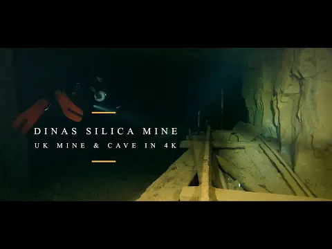
South Wales and Mendip, Great Britain · about 3 km from Glynneath
Dinas Silica Mine (Upper Dinas)
- Max depth23 m
- CertificationIntro to cave
- Water temperature≈ ~7 °Cestimated, no reports yet
- SpecialFlooded mine or quarry
Diving and fills
Dive here with
No dive centre guides here yet. Do you dive here with guests? Add your centre for free →
Fills nearby
- Fill stationThe Lake (Cromhall Quarry)Air (232 and 300 bar), nitrox (22–100 %), oxygen and 'mixed gas'; which mixes exactly is not stated — askRoute ↗
What it looks like
UK Cave Diving - Dinas Silica Mine in 4K Dinas Silica Mine Diving full HD Dinas Silica Mine Dinas Silica Mine Diving in 4K
All 4 videos and posts
Videos and posts
From other divers, via YouTube, Instagram and Facebook. They only load when you click; after that, Google's or Meta's privacy rules apply.
UK Cave Diving - Dinas Silica Mine in 4K Dinas Silica Mine Diving full HD Dinas Silica Mine Dinas Silica Mine Diving in 4K
Search for more onYouTube ↗Instagram ↗Facebook ↗
Other people's footage, not advice: how someone else dives here says nothing about what suits your team. Dive within your training.
The dive
You dive the levels below level 'A' of a pillar-and-stall mine with large chambers. The still water is ~7 °C and visibility usually very good, even after bad weather.
Profile and sections
You dive the levels below level 'A' of a pillar-and-stall mine with large chambers. The still water is ~7 °C and visibility usually very good, even after bad weather. The flooded workings are about 3 m from floor to roof, so careful buoyancy keeps it clear; old mining tools and miners' tea mugs are said to remain in place (Caving Wales). It is a popular first mine dive for trainees, and according to UKMC, Martyn Farr called it arguably the finest mine dive in the British Isles.
Silica was worked here until 1964: very pure sandstone for refractory 'Dinas' bricks.
- Depth and profile
- Six flooded levels 80–250 m long, down to ~-23 m (UKMC; another source ~-22 m), shallowest ~-3 m; depth varies with rainfall. Circuits: Western Tour 962 m, Eastern Tour 3,240 m, Grand Tour 3,965 m.
- Configuration
- All configurations; the walk and the carry to the dive base make sidemount (or sidemount CCR) the most practical. Backmount works but is heavy to carry in.
- DPV: DPV possible (estimate)
- Circuits of up to almost 4 km make a scooter attractive, but it has to be walked in for 15 min and carried underground; the owner's rules on scooters are unknown.
Who can dive where
- At least Intro to cave
- Configurations: Backmount / twinset / Sidemount / CCR / Small cylinders / no-mount (speleo sumps)
- Goes down to 23 m (trimix or deco may be needed)
This is how the planner decides who in your team may dive this cave. Rules your own trip adds (organizer, a mail, the AI) show with your trip.
How to get there
Ask for permission first. According to Caving Wales (Nov 2026) the landowner is the Welsh Government, represented by Natural Resources Wales (NRW), and the mine is on government forestry land: the entrance is publicly accessible, but entering a mine on government forestry is only legal with explicit permission or where a local sign allows it. Permission is requested in writing from NRW's Land Agent (NRW offices, Resolven, Neath, SA11 4DR); Caving Wales expects such a request to get nowhere. TDI writes that no formal permission and no CDG membership is needed, and according to the Cambrian Mines Trust the mine has belonged since 2015 to Natural Amenities Ltd, linked to the Cambrian Mines Trust, which aims to keep underground access open for cavers and mine explorers; the owner calls the flooded lower levels a popular venue for cave and mine divers. ~15 min walk from the car (steep and rocky at first, then easy) and ~80 m underground to the dive base, carrying all your kit. 13 entrances: 3 facing the river, 10 on the north side.
Around Dinas Silica Mine (Upper Dinas)
Fills1 fill station · 80 km
The Lake (Cromhall Quarry)
Cromhall Quarry, Wotton Road, South Gloucestershire GL12 8AA
Air (232 and 300 bar), nitrox (22–100 %), oxygen and 'mixed gas'; which mixes exactly is not stated — ask
Workshop Wed, Thu, Sat and Sun 8:00–15:00
Dive lake in a former quarry (max -17 m) with a technical department (IDEST-certified) for fills, servicing and cylinder testing; the workshop is by the quarry entrance. Diving at weekends, no solo diving. Not a dive school. No phone number or e-mail address on the website: contact through the form.
The links to Booking.com are affiliate links: if you book through one, DiveTripPlanner earns a small commission. You pay the same.
Caves nearby2 within 30 km
Going to South Wales and Mendip with your team?
Marcel finds the sites that match your team's certifications.
Plan a trip