
Alto Tajo & Serranía de Cuenca · about 8 km from Beteta
Surgencia de Fuentenavina (Fuente Navina)
- Max depth44 m
- CertificationFull cave
- Water temperature≈ 10–11 °Cestimated, no reports yet
- SpecialSidemount
Diving and fills
Dive here with
No dive centre guides here yet. Do you dive here with guests? Add your centre for free →
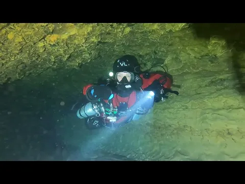
What it looks like
Cave Diving Fuentenavina, Spain CAVE DIVING IN SPAIN-ESPELEOBUCEO-FUENTENAVINA Fuentenavina hilo principal Fuentenavina Solo + DPV
All 4 videos and posts
Videos and posts
From other divers, via YouTube, Instagram and Facebook. They only load when you click; after that, Google's or Meta's privacy rules apply.
Cave Diving Fuentenavina, Spain CAVE DIVING IN SPAIN-ESPELEOBUCEO-FUENTENAVINA Fuentenavina hilo principal Fuentenavina Solo + DPV
Search for more onYouTube ↗Instagram ↗Facebook ↗
Other people's footage, not advice: how someone else dives here says nothing about what suits your team. Dive within your training.
The dive
The water is 10–11 °C. Visibility gets poor towards the end of the main gallery. According to GAEM this is the largest sump in central Spain.
1 earlier accident or incident has been reported at this cave. Read what happened ↓
Profile and sections
The water is 10–11 °C. Visibility gets poor towards the end of the main gallery.
According to GAEM this is the largest sump in central Spain. GAEM (Madrid) has explored it since 1995 with other clubs; in 2023 the Piedruca gallery connected the sumps.
Practical: the spring lies at an altitude of ~1,205 m, so set your computer for it.
- Depth and profile
- Main gallery 870 m / -43 m (impassable end) · Escalón gallery 536 m / -27.5 m to an air bell · S2 160 m / -36 m · max ~-44 m · >1,500 m of underwater passage explored
- Configuration
- Sidemount recommended: the passage starts at ~1.7 × 1.2 m; backmount is tight (estimate)
- DPV: Not DPV-suitable (estimate)
- Tight passage (~1.7 × 1.2 m) and poor visibility further in; little gain
Who can dive where
- At least Full cave
- Configurations: Backmount / twinset / Sidemount / CCR / Small cylinders / no-mount (speleo sumps)
- Goes down to 44 m (trimix or deco may be needed)
- Experienced divers only
This is how the planner decides who in your team may dive this cave. Rules your own trip adds (organizer, a mail, the AI) show with your trip.
How to get there
Small opening ~10 m behind the spring outlet, on the left bank of the Tajo in the Parque Natural del Alto Tajo, at ~1,205 m altitude. Groups of more than 3 and exploration need authorisation from the Delegación Provincial (Guadalajara); scuba diving has its own rule in the park plan — request permission in advance.
Around Surgencia de Fuentenavina (Fuente Navina)
FillsNo fill station known nearby
The links to Booking.com are affiliate links: if you book through one, DiveTripPlanner earns a small commission. You pay the same.
News
All (1)
Accidents and incidents
What happened at this cave before, with the sources. No names are given; read it as a lesson for your own planning.
- Fatal accident on 26 October 2019: a diver did not return from a solo dive; Guardia Civil divers (GEAS Madrid and Cuenca) recovered him during the night.
Access and rules change: check what applies locally right before your trip. Source: GDELT Project and the news feeds of diving magazines. Search for more news ↗ Searched automatically, last on 13 Nov 2026.
More of the latest in Alto Tajo and Serranía de Cuenca (Spain): conditions, closures and news →Going to the Alto Tajo and the Serranía de Cuenca with your team?
Marcel finds the sites that match your team's certifications.
Plan a trip