
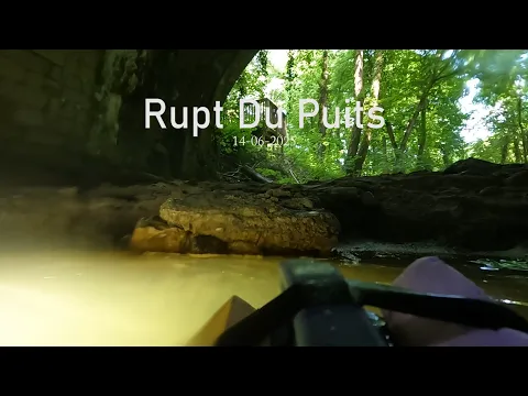
Barrois · about 4 km from L'Isle-en-Rigault
Vasque du Rupt-du-Puits
- Max depth11 m
- CertificationFull cave
- Water temperature≈ 8–11.5 °Cestimated, no reports yet
- SpecialSidemount
Diving and fills
Dive here with
No dive centre guides here yet. Do you dive here with guests? Add your centre for free →
What it looks like
All 2 videos and posts
Videos and posts
From other divers, via YouTube, Instagram and Facebook. They only load when you click; after that, Google's or Meta's privacy rules apply.
- Facebook
Spéléo club Les Sans Ciel
Search for more onYouTube ↗Instagram ↗Facebook ↗
Other people's footage, not advice: how someone else dives here says nothing about what suits your team. Dive within your training.
The dive
The pool is always full but only flows in floods. Visibility is moderate to poor because of clay and near zero after storms; in good conditions it is clear.
Profile and sections
The pool is always full but only flows in floods. Visibility is moderate to poor because of clay and near zero after storms; in good conditions it is clear. The water is 11.5 °C (measured in 1967; a 1970s account gives 8 °C).
This is the overflow spring of the Rupt-du-Puits, according to the Meuse département the largest cave in the Paris Basin. The permanent spring is the Rupt-de-Frainiau (private, the owner refuses any digging). The pool was first passed in 1971. Local clubs still dive it: in June 2026 the GERSM searched for side passages here at a flow of ~11 l/s (March 2026 peak: ~1,960 l/s).
- Depth and profile
- Downstream from the pool: sump of 445 m / -4 (Wikipedia). plongeesout splits it into S1 97 m · S2 91 m · S3 68 m · S4 259 m, lowest point -8 m (another sheet: -11 m). Beyond: over 11 km of dry passage; the whole system is 17.4 km to over 21 km (sources differ).
- Configuration
- S1 starts with low passages between boulders; in the 1970s this was a rising squeeze in rubble 35–110 cm high. Then 3–4 m wide and 2–3 m high. Sidemount or small cylinders; backmount and CCR only if you know the entrance (estimate).
- DPV: DPV possible
- In June 2026 the GERSM used a scooter here (~400 m in 36 min). The low entrance and clay-laden visibility limit the gain (estimate).
Who can dive where
- At least Full cave
- Configurations: Backmount / twinset / Sidemount / CCR / Small cylinders / no-mount (speleo sumps)
- Goes down to 11 m (trimix or deco may be needed)
- Experienced divers only
This is how the planner decides who in your team may dive this cave. Rules your own trip adds (organizer, a mail, the AI) show with your trip.
How to get there
Pool under a masonry arch of a disused railway line, ~300 m outside Robert-Espagne at the bottom of a dry valley; the Beurey-sur-Saulx/Robert-Espagne karst trail passes the springs. No permit or ban known. The permanent lines belong to local explorers: contact CDS 55 (cd.speleo.55@gmail.com) or the GERSM beforehand.
Around Vasque du Rupt-du-Puits
FillsNo fill station known nearby
The links to Booking.com are affiliate links: if you book through one, DiveTripPlanner earns a small commission. You pay the same.
Going to the Barrois with your team?
Marcel finds the sites that match your team's certifications.
Plan a trip